
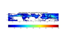
Megha- Tropiques (MT) is a joint Indo-French collaborative satellite mission, which is launched on 12 October 2011. The main objective of MT is to get more understanding on convective system, energy exchange and water cycle in the tropical region. It is equipped with Microwave Analysis and Detection of Rain and Atmospheric Structures (MADRAS) (not in operational), Scanner for Radiation Budget, Radio Occultation Sensor for Atmosphere and Sondeur Atmospherique du Profil d’Humidite Intertropical par Radiometrie (SAPHIR). SAPHIR provides clear sky atmospheric humidity profiles at 6-channels near 183.31GHz water vapour resonance. The observations of SAPHIR provides an opportunity to estimate rainfall using 183.31GHz channels. A Bayesian based rainfall retrieval technique is developed using SAPHIR channel-6 (183.31±11GHz) brightness temperature observations. Estimated rainfall has been validated with IMERG and DPR products during Jan-Dec 2017. The global distribution of rainfall patterns are captured well by the estimation.
Data Access
Click Here to access the Science Products. Request to use MOSDAC Single Sign On user credentials to download the data.
Data Version
- Version 1.1 (beta)
Data Sources
- SAPHIR Level 1A TB data
Processing Steps
- SAPHIR Level-1 brightness temperature of channel-6 (Tb6) and spatial variability of Tb6 (Std-tb6) within ±3 pixels (~30km at nadir and ~60km off nadir) is calculated.
Bayesian algorithm is trained using GPM-IMERG half hourly rainfall Bayesian approach is applied to estimate rainfall from SAPHIR sounder observations.
References
- Kummerow, C.D., W. S. Olson, and L. Giglio, A simplified scheme for obtaining precipitation and vertical hydrometeor profiles from passive microwave sensors, IEEE Trans. Geosci. Remote Sens., vol. 34, no. 5, pp. 1213–1232, Sep. 1996.
Pierdicca, N., F. S. Marzano, G. D’Auria, P. Basili, P. Ciotti, and A. Mugnai, Precipitation retrieval from spaceborne microwave radiometers using maximum a posteriori probability estimation, IEEE Trans. Geosci. Remote Sens., vol. 34, no. 4, pp. 831–846, Jul. 1996.
Olson, W.S., C. D. Kummerow, G. M. Heymsfield, and L. Giglio, A method for combined passive-active microwave retrievals of cloud and precipitation parameters, J. Appl. Meteorol., vol. 35, pp. 1763–1789, 1996.
Marzano, F.S., A. Mugnai, G. Panegrossi, N. Pierdicca, E. A. Smith, and J. Turk, Bayesian estimation of precipitating cloud parameters from combined measurements of spaceborne microwave radiometer and radar, IEEE Trans. Geosci. Remote Sens., vol. 37, no. 1, pp. 596–613, Jan. 1999.
Viltard, N., C. Burlaud, and C. D. Kummerow, Rain retrieval from TMI brightness temperature measurements using a TRMM PR–based database. J. Appl. Meteor. Climatol, 45, 455–466, doi:10.1175/JAM2346.1, 2006.
Gopalan, K., N.-Y. Wang, R. Ferraro, and C. Liu, Status of the TRMM 2A12 land precipitation algorithm. J. Atmos. Oceanic Technol., 27, 1343–1354, doi:10.1175/2010JTECHA1454.1, 2010.
Derivation Techniques and Algorithm
- User should refer report “Rainfall Estimation from Megha-Tropiques Microwave Sounder-SAPHIR using Bayesian Approach” for complete reference to the algorithm.
Limitations
- Rainfall estimates are not provided in the 3 outermost scan positions of the SAPHIR scan.
Known problems with data
- No known issues at this time.
File Naming Convention
HDF5 file:
MTSAPS__VVV_*_YYYY_MM_DD_*.Bayesian_RR.h5
VVV is the Level 1 version number
YYYY is the year, MM is the month and DD is the date of the orbit.
| Sr. No | Core Metadata Elements | Definition |
| 1 | Metadata language | English |
| 2 | Metadata Contact | MOSDAC |
| 3 | Metadata date | June 2018 |
| 4 | Data Lineage or Quality | Rain Rate |
| 5 | Title | Bayesian based MT-SAPHIR rainfall |
| 6 | Abstract | Megha- Tropiques (MT) is a joint Indo-French collaborative satellite mission, which is launched on 12 October 2011. The main objective of MT is to get more understanding on convective system, energy exchange and water cycle in the tropical region. It is equipped with Microwave Analysis and Detection of Rain and Atmospheric Structures (MADRAS) (not in operational), Scanner for Radiation Budget and Radio Occultation Sensor for Atmosphere and Sondeur Atmospherique du Profil d’Humidite Intertropical par Radiometrie (SAPHIR). SAPHIR provides clear sky atmospheric humidity profiles at 6-channels near 183.31GHz water vapour resonance. The observations of SAPHIR provides an opportunity to estimate rainfall using 183.31GHz channels. A Bayesian based rainfall retrieval technique is developed using SAPHIR channel-6 (183.31±11GHz) brightness temperature observations. Estimated rainfall has been validated with IMERG and DPR products during Jan-Dec 2017. The global distribution of rainfall patterns are captured well by the estimation. |
| 7 | Dataset Contact | Neerja Sharma and Kaushik Gopalan, GRD/AOSG/EPSA, Space Applications Centre (ISRO), Ahmedabad, 380015, kaushikg@sac.isro.gov.in |
| 8 | Update Frequency | January 2017 to May 2018 have been processed. Data will be updated daily with ~24 hours lag. |
| 9 | Access Rights or Restriction | Open Access |
| 10 | Spatial Resolution | Data is provided at native spatial resolution of the SAPHIR instrument. |
| 11 | Language | English |
| 12 | Topic Category | Rainfall |
| 13 | Keywords | Microwave sounder, Bayesian technique, rainfall |
| 14 | Date or period | From January 2017 onwards. |
| 15 | Responsible Party | Neerja Sharma and Kaushik Gopalan,GRD/AOGG/ EPSA, Space Applications Centre (ISRO), Ahmedabad-380015, India |
| 16 | Organization | Space Applications Centre (ISRO), Ahmedabad, India |
| 16a | Org. role | Rainfall retrieval from MT-SAPHIR observations |
| 16b | Individual name |
Neerja Sharma, GRD/AOSG/EPSA, SAC(ISRO), Ahmedabad-380015, India. Ph:+91 79 26916115. Email:neerjasharma@sac.isro.gov.in Kaushik Gopalan, GRD/AOSG/EPSA, SAC (ISRO), Ahmedabad-380015, India. Ph: +91 79 2691 6110. Email: kaushikg@sac.isro.gov.in |
| 16c | Position | Scientist/Engineer, GRD/AOSG/EPSA, SAC (ISRO), Ahmedabad-380015 |
| 16d | Vertical Extent (minimumValue, maximumValue, unitOfMeasure, vertical datum) | NA |
| 17 | Geographic Extent | Tropical region (28S to 28N) |
| 18 | Geographic name, geographic Identifier | lat_min: 28S, lat_max: 28N, lon_min: 0, lon_max: 360 |
| 19 | Bounding box | lat_min: 28S, lat_max: 28N, lon_min: 0, lon_max: 360 |
| 20 | Temporal Extent | January 2017 onwards |
| 21 | Access Rights or Restrictions | Open Access |
| 22 | Distribution Information | Online download of data files in HDF5 format |
| 23 | Processing Level | Level 2 (Data product derived from MT SAPHIR) |
| 24 | Reference System | Datum: WGS84 |