
It is crucial to know how the storage of inland water bodies change over time. Also, hydrological modelling studies face the challenge of decreasing availability of in-situ monitoring data. However, application of satellite radar altimetry over the inland water bodies becomes vital tool to estimate water levels through waveform retracking on satellite altimetry?s sensor data. SARAL-Altika was launched on 25 February 2013. It is a joint-mission of CNES France and ISRO to provide continuous monitoring of ocean and continental water surface. It was launched into a Sun synchronous polar orbit at an altitude of 790km with 35 days of orbit repetition and follows same ground track as ENVISAT satellite. It has 98.55 deg of inclination with 75 km of equatorial cross track separation. It has Ka-band (35.75 GHz) radar altimeter. Water level product for inland water bodies (presently for Brahmaputra river and Ukai Reservoir) has been generated using the SARAL-ALTIKA waveform data.
Data Access
Click Here to access the Science Products . Request to use MOSDAC Single Sign On user credentials to download the data.
Data Version
- Version 1.0 (beta)
Data Sources
- Altimeter Interim Geophysical Data Record (IGDR)
- Geophysical Data Record (GDR)
- ECMWF Pressure Fields
- Global Ionosphere Maps (GIM) produced Total Electron Content (TEC) maps
Processing Steps
- Firstly the waveforms are classified based on their signature, and then these waveforms are retracked with the suitable retracker.
- Dedicated inland range correction algorithms are required to account for the atmospheric delays.Detailed information about the processing can be found in (S. Chanderet. al. 2014, A .Dubey et. al. 2014).
References
- S. Chander, and P Chauhan (2013). Algorithm Theoretical BasisDocument for SARAL/AltiKa data processing for geophysical parametersretrieval, scientific report no. EPSA/MPSG/PMD/2013/01.
- S Chander, D Ganguly, AK Dubey, PK Gupta, RP Singh and P Chauhan(2014).Inland water bodies monitoring using satellite altimetry overIndian region, The International Archives of the Photogrammetry, Remote Sensing and Spatial Information Sciences, Volume XL-8, 2014, ISPRS Technical Commission VIII Symposium, 09 ? 12 December 2014, Hyderabad, India.
- A K Dubey, P K Gupta, S Dutta and R P Singh (2015). Water Level Retrieval using SARAL/AltiKa Observations in the Braided Brahmaputra River, Eastern India, Marine Geodesy, DOI: 10.1080/01490419.2015.1008156
- D Ganguly, S Chander, S Deasi and P Chauhan. Optimal waveform retracker for inland water bodies: A case study over Ukai Dam/Reservoir, is under review in the journal of Marine Geodesy.
- P K Gupta, A K Dubey, N Goswami, R P Singh and P Chauhan (2015): Use of SARAL/AltiKa Observations for Modeling River Flow. Marine Geodesy (accepted).
Derivation Techniques and Algorithm
- The water level over the inland water bodies can be retrieved using altimeter waveforms data.
- The range information is estimated based on the arrival time of the radar pulse.
- This range is then corrected for Dry tropospheric correction, wet tropospheric correction, ionospheric correction, and tidal correction, i.e. Load tide, solid earth tide.
- Detailed information about the range corrections can be found in the ATBD document (S. Chander and Prakash Chauhan, 2013) of the SARAL mission.
Limitations
- Based on the availability of the Altimeter dataset over the study region (Data Gap, altimeter track loss, bad weather, etc.).
Known problems with data
- Data problems due to bad weather (heavy rain)
Related data collections
- GPS Field trip for water level measurement was conducted over Ukai reservoir on 9th November 2013, 17th January 2014 and 2nd January 2015.
- Brahmaputra observed river water level data was collected for 6 locations from upstream to downstream from Inland Waterways Authority (IWAI) and Central Water Commission (CWC) along with the satellite pass synchronous field trips.
File Naming Convention
- altimeter_derived_water_height_ukai_yyyymmdd_v1
| Sr. No | Core Metadata Elements | Definition |
| 1 | Metadata language | English |
| 2 | Metadata Contact | MOSDAC |
| 3 | Metadata date | March 05, 2015 |
| 4 | Data Lineage or Quality | Water height estimation over inland water bodies using radar altimeters |
| 5 | Title | Inland Water Bodies Monitoring using Satellite Altimetry over Indian Region |
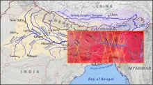
| 6 | Abstract | Inland water bodies? heightshave been estimated using SARAl-Altika and Jason-2 data over the two test sites, i.e. Ukai reservoir and Brahmaputra River (10 sites from upstream to downstream locations within the Indian region). The results were matched with the in-situ data collected from the GPS field trips and observed data collected from IWAI and CWC. In the first phase results of these two sites are presented herewith. Such 29 inland water bodies with (49 locations) are being done in the phase manner |
| 7 | Dataset Contact | Shard Chander and D Gangulay, PMD/BPSG/EPSA, Praveen Gupta and Amit Dubey, EHD/BPSG/EPSA SAC (ISRO), Ahmedabad-380015, India. Ph: +91 79 2691 4138. Email: pkgupta@sac.isro.gov.in; schander@sac.isro.gov.in |
| 8 | Update Frequency | Near real time after the altimeter pass over the study area (35 days repetivity) |
| 9 | Access Rights or Restriction | Open Access |
| 10 | Spatial Resolution | NA |
| 11 | Language | English |
| 12 | Topic Category | Inland water bodies monitoring |
| 13 | Keywords | Rivers/reservoirs, Satellite altimetry, waveform retracking, geophysical range corrections, water levels |
| 14 | Date or period | Since launch of SARAL-Altika (February 2013) |
| 15 | Responsible Party | Dr.Prakash Chauhan, Biological and Planetary Sciences Group, EPSA, Space Applications Centre (ISRO), Ahmedabad-380015, India |
| 16 | Organization | Space Applications Centre (ISRO), Ahmedabad, India |
| 16a | Org. role | Retrieval of water level using Remote sensing techniques |
| 16b | Individual name | D. Ram Rajak, OSD/AOSG/EPSA, SAC (ISRO), Ahmedabad-380015, India. Ph: +91 79 2691 6051. Email: rajakdr@sac.isro.gov.in |
| 16c | Position | Scientist/Engineer, OSD/AOSG/EPSA, SAC (ISRO), Ahmedabad-380015, India. Ph: +91 79 2691 6051. Email: rajakdr@sac.isro.gov.in |
| 16d | Vertical Extent (minimumValue, maximumValue, unitOfMeasure, vertical datum) | Default value =NaN Unitofmeasurement= meter Datum: WGS84 |
| 17 | Geographic Extent | UL Coordinates: 40N, 65E. UR Coordinates: 40N, 100E. LL Coordinates: 5, 65E. LR Coordinates: 5, 100E. |
| 18 | Geographic name, geographic Identifier | Indian Region |
| 19 | Bounding box | UL Coordinates: 40N, 65E. UR Coordinates: 40N, 105E. LL Coordinates: 5, 65E. LR Coordinates: 5, 105E. |
| 20 | Temporal Extent | Historical time series plot of water heights over inland water body since the availability of altimeter measurement |
| 21 | Access Rights or Restrictions | Open Access |
| 22 | Distribution Information | Online download in text, and PNG formats |
| 23 | Processing Level | Level 3 (Data product derived from altimeter IGDR/GDR product) |
| 24 | Reference System | Datum: WGS84 |