
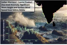
SARAL/AltiKa was launched on 25 February 2013 as a joint collaboration mission of ISRO and CNES. With smaller footprint than earlier satellite altimeters, SARAL/AltiKa has improved coastal performance. Specific waveform processing has been used in this product to derive along track geophysical parameters (Sea Surface Height, Significant wave height and wind speed) from the altimeter 40-Hz waveform data. This product is generated for Indian mainland coastal region (up to 50 km from the coast). This product is available for 35 cycles of SARAL/AltiKa starting from March 2013 through July 2016.
Data Access
Click Here to access the Science Products . Request to use MOSDAC Single Sign On user credentials to download the data.
Data Version
- Version 1.1 (Beta)
Data Sources
- Altimeter Sensor-Interim Geophysical Data Record (S-IGDR)
- Indian Ocean Bathymetry
- Indian Ocean Geoid
- High resolution coastline
Processing Steps
- i. High resolution bathymetry is used to separate the coastal and land waveforms.
- ii. Waveforms are classified based on their shape.
- iii. Waveforms are retracked with the beta parameter retrackers (BETA5 and BETA9) and BAGP (Brown with asymmetric Gaussian Peak) retracker to get sea surface height (SSH), sea surface height anomaly (SSHA), significant wave height (SWH) and wind speed.
- iv. Using Significant Wave Height (SWH) and wind speed, the wave period is derived based on the data adaptive technique of " Genetic Algorithm " (Remya et al. 2011)
- v. Wave power is derived based on SWH and estimated wave period. 40 Hz data is filtered using a lanczos filter to remove high frequency noise.
- vi. Wind power is calculated using standard wind power formula. 40 Hz data is filtered using a lanczos filter to remove high frequency noise.
References
- Amarouche L, Thibaut P, Zanife O.-Z, Dumont, P. Vincent J.-P. and Steunou N 2004. Improving the Jason-1 ground retracking to better account for attitude effects, Mar. Geod. 27: 171-197.
- Brown, G. S. 1977. The Average impulse response of a rough surface and its applications, IEEE Trans. Antennas Propag. AP-25: 67-74.
- Chelton, D. B., J. C. Ries, B. J. Haines, L. L. Fu, and P. S. Callahan, 2001, “Satellite Altimetry”,
- Satellite Altimetry and Earth Sciences, ed. L.L. Fu and A. Cazenave, pp. 1-131.
- Chaudhary A., Basu S., Kumar R, Mahesh, C. and Sharma R. 2015.” Shape classification of AltiKa 40-Hz waveforms using Linear Discriminant Analysis and Bayes Decision Rule in the Gujarat Coastal region “Marine Geodesy.
- Coastal and Hydrology Altimetry product (PISTACH) handbook, CLS-DOS-NT-10-246, SALP-MU-P-OP-16031-CN 01/00, 1. 0, Oct. 4, 2010
- Deng, X., and W. E. Featherstone. 2006. A coastal retracking system for satellite radar altimeter waveforms: Application to ERS-2 around Australia. J. Geophys. Res. 111: doi:10.1029/2005JC003039.
- Deng, X. 2003. “Improvement of geodetic parameter estimation in coastal regions from satellite radar altimetry.” PhD. Dissertation, Curtin University of Technology, Perth, Australia.
- Halimi, A., C. Mailhes, J. – Y. Tourneret, P. Thibaut, and F. Boy. 2013. Parameter estimation for peaky altimetric waveforms. IEEE Trans. Geosci. Rem. Sens., 51: 1568-1577.
- The PISTACH project for coastal altimetry: Status, products and early results, in Proc. OST-ST Meeting, Seattle, WA.
- Nelder, J.A. and Mead R. 1965. A simplex method for function minimization. Computer Journal, vol 7, no. 4, 308-313.
- Ray, R. D., 1999, A global ocean tide model from TOPEX/POSEIDON altimetry: GOT99.2, NASA Tech. Memorandum 1999-209478, Goddard Space Flight Center, Greenbelt, MD.
- SARAL/AltiKa Products Handbook, SALP-MU-M-OP-15984-CN, 2, 4, December 9, 2013
- Remya, G., Kumar, R., Basu, S., & Sarkar, A. (2011). Altimeter-derived ocean wave period using genetic algorithm. IEEE Geoscience and Remote Sensing Letters, 8(2), 354-358.
- R. Govindan, R. Kumar, S. Basu and A. Sarkar. " Altimeter-Derived Ocean Wave Period Using Genetic Algorithm, " IEEE Geosci. Remote Sens. Lett.,VOL 8.NO. 2,pp. 354 - 358, March 2011
- Sindhu, B., I. Suresh, A. S. Unnikrishnan, N. V. Bhatkar, S.Neetu and G. S. Michael 2007. Improved bathymetric data sets for the shallow water regions in the Indian Ocean. J. Earth Syst. Sci.,116,61–274.
- Sreejith, K.M., Rajesh, S., Majumdar, T.J., Srinivasa Rao G., Radhakrishna, M., Krishna, K.S., Rajawat A.S., 2013. High-resolution residual geoid and gravity anomaly data of the northern Indian Ocean - an input to geological understanding. J. Asian Earth Sci. 62, 616–626.
Derivation Techniques and Algorithm
- User should refer User Handbook “Moving closer to the coast by SARAL/AltiKa: Geophysical Product for Indian Mainland Region” for complete reference to the algorithm and processing steps. For Handbook SARAL/AltiKa: Geophysical Product for Indian Mainland Region (Size: 1.14MB Format: PDF Tool: PDFView) Click Here
- For value added wave product:
- The wave power (P) is mathematically derived as
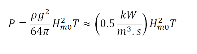
- Where
- 1. P is Wave power per unit of wave-crest length (in Kilowatt/m)
- 2. R represents the satellite range
- 3. H m0 is the significant wave height (in meters)
- 4. T is wave period (in seconds)
- 5. ρ is the density of water (in kilogram/cubic meter)
- 6. g is the acceleration due to gravity (in meters/square seconds)
- Wind power is generated by using;
- We have assumed unit area in this equation. is density of air and is wind speed.
Limitations
- Based on the availability of the Altimeter dataset over the study region (Data Gap, altimeter track loss, bad weather, etc.). Geophysical and atmospheric range corrections have been obtained from the standard 1-Hz product of SARAL/AltiKa.
Known problems with data
- Data problems due to bad weather (heavy rain).
- Onboard tracker failure leads to unusable data.
- Coastal contamination may lead to erroneous estimate of the derived parameters.
File Naming Convention
- Netcdf file:
- SRL_CCC_TTTT_yyyymmddHHMMSS_yyyymmddHHMMSS_INDIANCOAST_SIGDR_VER1.1.nc;
- JPG Files:
- ssha_cycCCC_yyyymmdd_yymmdd.jpg (sea surface height anomaly image)
- swh_cycCCC_yyyymmdd_yymmdd.jpg (swh image)
- wind_speed_cycCCC_yyyymmdd_yymmdd.jpg (wind speed image)
- Where
- CCC is the cycle number and TTTT is the track number.,
- first yyyymmddHHMMSS is the start time of the file., and
- second yyyymmddHHMMSS is the end time of the file..
- For values added wind wave power product:
- wind_power_cycCCC_yyyymmdd_yymmdd.jpg (wind power image)
- wave_power_cycCCC_yyyymmdd_yymmdd.jpg (wave power image)
| Sr.No | Core Metadata Elements | Definition |
| 1 | Metadata language | English |
| 2 | Metadata Contact | MOSDAC |
| 3 | Metadata date | October, 2016 |
| 4 | Data Lineage or Quality | Sea surface height, Significant wave height, wind speed in coastal regions using radar altimeters and wind wave power derived in coastal region. |
| 5 | Title | SARAL/AltiKa Coastal Product (Indian region) and Wind Wave Power product |
| 6 | Abstract | SARAL, a joint ISRO-CNES satellite mission, was successfully launched in 2013. It carries a Ka band single frequency satellite altimeter (AltiKa). Satellite altimeters are primarily used to study sea level changes. In the open ocean, the altimetric echo follows a standard shape, with steeply rising leading edge followed by a trailing edge with gradually diminishing power. This standard shape is in agreement with the theoretical Brown model and hence can be easily modeled. However, in the coastal areas, due to the presence of land and other coastal featues in the footprint of the altimeter, contamination occurs and the return is different from open ocean. Up to some extent these contaminations can be modeled. Footprint size of SARAL/Altika is small which is ideal for coastal studies. The available ocean retracker (MLE4) itself shows good performance near the coast. However, further improvemnts can be achieved by using algorithms which can simulate contaminations impact in the coastal areas. In this document we have used various models for the return waveforms at 40 Hz to extract maximum information from the altimeter. Our results show that algorithms which are useful in the coastal areas are BETA5, BETA9 and Brown with Asymmetric Gaussian Peak (BAGP). Additionally, a wind power and wave power product has also been generated from this coastal product. |
| 7 | Dataset Contact | Aditya Chaudhary, OSD/AOSG/EPSA, Space Applications Centre (ISRO), Ahmedabad 380015, aditya.osd@sac.isro.gov.in |
| 8 | Update Frequency | 35 cycles of SARAL/AltiKa have been processed. After this, cycles are not in exact repeat mode. |
| 9 | Access Rights or Restriction | Open Access |
| 10 | Spatial Resolution | Data is provided at 40 Hz which corresponds to spatial resolution of nearly 180m. |
| 11 | Language | English |
| 12 | Topic Category | Coastal Altimetry |
| 13 | Keywords | Satellite altimetry, waveform retracking, sea level, significant wave height, waveform classification |
| 14 | Date or period | Cycle 1 to Cycle 35 of SARAL/AltiKa (March 2013 to July 2016) |
| 15 | Responsible Party | Aditya Chaudhary, OSD/AOGG/ EPSA, Space Applications Centre (ISRO), Ahmedabad-380015, India |
| 16 | Organization | Space Applications Centre (ISRO), Ahmedabad, India |
| 16a | Org. role | Retreival of Geophysical parameters from satellite altimeter over the Indian Coast |
| 16b | Individual name | Aditya Chaudhary, OSD/AOSG/EPSA, SAC (ISRO), Ahmedabad-380015, India. Ph: +91 79 2691 6051. Email: Aditya.osd@sac.isro.gov.in |
| 16c | Position | Scientist/Engineer, OSD/AOSG/EPSA, SAC (ISRO), Ahmedabad-380015, India. Ph: +91 79 2691 6051. Email: aditya.osd@sac.isro.gov.in |
| 17 | Geographic Extent | lat_min: 05N, lat_max: 24N, lon_min: 68E, lon_max: 90E |
| 18 | Geographic name, geographic Identifier | Indian Coastal Region |
| 19 | Bounding box | lat_min: 05N, lat_max: 24N, lon_min: 68E, lon_max: 90E |
| 20 | Temporal Extent | March 2013 to July 2016 |
| 21 | Access Rights or Restrictions | Open Access |
| 22 | Distribution Information | Online download in netcdf formats. |
| 23 | Processing Level | Level 3 (Data product derived from altimeter S-IGDR product) |
| 24 | Reference System | Datum: WGS84 |